HTTP 200 OK
Allow: GET, PUT, PATCH, DELETE, HEAD, OPTIONS
Content-Type: application/json
Vary: Accept
{
"url": "https://awgrym.controlledfrenzy.co.uk/api/image/263900ab-2aa3-438d-b13b-02b060434b23/?format=api",
"ImageURL": "https://rmv-public.s3.eu-west-2.amazonaws.com/sidTest/flat/Deep-water%20anemones_SUB_D5_BER_PL_BEN_T3_0357_303m.jpg",
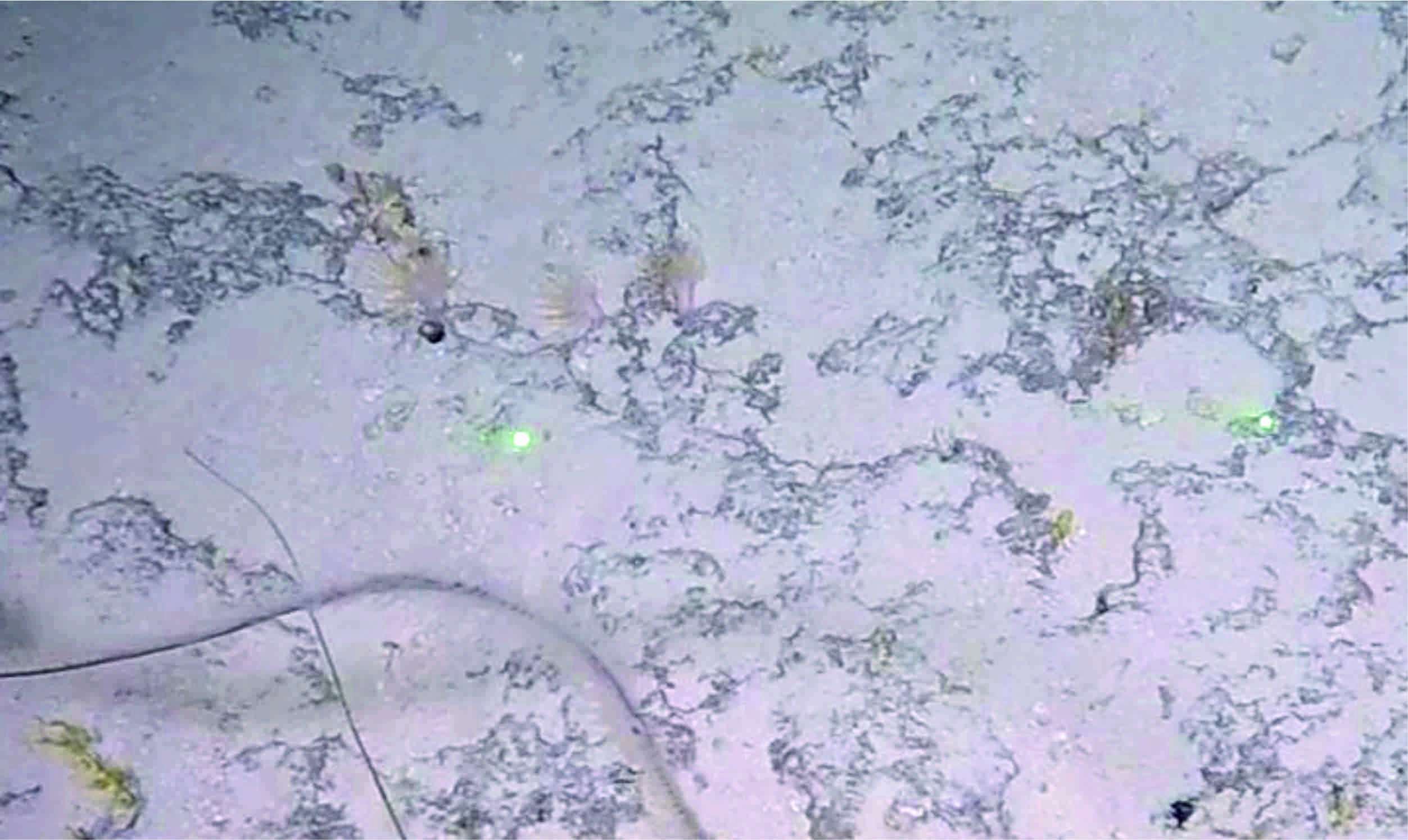
"ImageName": "Deep-water anemones_SUB_D5_BER_PL_BEN_T3_0357_303m",
"uuid": "263900ab-2aa3-438d-b13b-02b060434b23",
"region": "North Atlantic",
"importedFrom": "marinedata/AnemonesMerged.xlsx",
"insituImageName": "Deep-water anemones_SUB_D5_BER_PL_BEN_T3_0357_303m",
"insituImageURL": "https://rmv-public.s3.eu-west-2.amazonaws.com/sidTest/flat/Deep-water%20anemones_SUB_D5_BER_PL_BEN_T3_0357_303m.jpg",
"exsituImageName": null,
"exsituImageURL": null,
"physicalSample": null,
"imageCredits": "Paris Stefanoudis, Nekton",
"identifiedBy": "Paris Stefanoudis",
"dateIdentified": null,
"dateIdentifiedRaw": null,
"identificationRemarks": null,
"identificationVerificationStatus": null,
"typeStatus": null,
"rawImage": " ",
"locality": "Bermuda (32.2901°, -64.7632°)",
"locationID": 34793,
"locationURL": "https://www.marineregions.org/eezdetails.php?mrgid=34793",
"locationDataURL": "https://www.marineregions.org/rest/getGazetteerRecordByMRGID.json/34793/",
"locationData": {
"MRGID": 34793,
"status": "standard",
"accepted": 34793,
"latitude": 48.583333,
"longitude": -10.783333,
"placeType": "Canyon(s)",
"precision": null,
"maxLatitude": null,
"minLatitude": null,
"maxLongitude": null,
"minLongitude": null,
"gazetteerSource": "US BGN Advisory Committee on Undersea Features (ACUF)",
"preferredGazetteerName": "Whittard Canyon",
"preferredGazetteerNameLang": "English"
},
"locationDataUpdated": "2022-03-23T16:16:25.426662Z",
"locationRemarks": null,
"decimalLatitude": "32.2901000000",
"decimalLongitude": "64.7632000000",
"minimumDepthInMeters": "303.0000000000",
"maximumDepthInMeters": "303.0000000000",
"institutionID": "Nekton",
"collectionID": "Stefanoudis et al. 2018",
"bibliographicCitation": "Stefanoudis P.V., Smith S.R., Schneider C., Wagner D., Goodbody-Gringley G., Xavier J., Rivers M., Woodall L.C., Rogers A.D. 2018 Deep Reef Benthos of Bermuda: Field Identification Guide. (p. 168. figshare (https://doi.org/10.6084/m9.figshare.7333838.v1).",
"modified": null,
"dctermsLicense": null,
"dctermsRightsHolder": null,
"dctermsAccessRights": null,
"previousIdentifications": "BER_41",
"catalogNumber": null,
"associatedSequences": "Submarine slope",
"habitat": null,
"substrateType": null,
"size": null,
"substrateMethod": "Nekton Mission - XL Catlin Deep Ocean Survey",
"projectName": "https://doi.org/10.6084/m9.figshare.7333838",
"externalLink": null,
"situType": "I",
"added": "2022-03-23T16:16:25.650545Z",
"updated": "2022-04-06T15:09:30.430373+01:00",
"OTU": "https://awgrym.controlledfrenzy.co.uk/api/otu/c58d8066-82c5-4c19-973f-c44d84149c1c/?format=api"
}